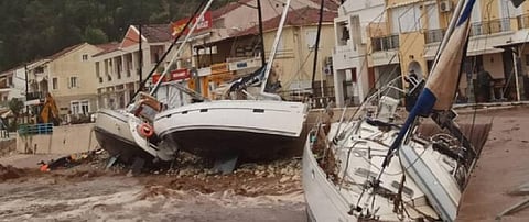

Extra tropical storms in the Mediterranean Sea, known as ‘Medicanes’ or ‘Mediterranean Hurricanes’, could become more frequent due to human-induced climate change, experts have warned.
On September 18, 2020, a medicane named Ianos made landfall along the coast of Greece and caused heavy rainfall and flooding on the islands of Zakynthos, Kefalonia and Ithaca. The wind speeds reached upto 100 kilometres per hour (km / hr).
The storm later moved to central Greece, where it wreaked havoc in the cities of Karditsa and Farsala, before moving onto the southern island of Crete by the night of September 19. The storm has killed three people till date.
Even though many media outlets reported it to be a rare occurrence and one of the strongest such storms on record, scientists said medicanes are not as rare but might become more frequent owing to global warming due to anthropogenic climate change.
This might also mean an increased threat from these storms for already vulnerable populations living in North Africa, possibly triggering human migration. They could also be a menace for European countries like Italy and Greece.
“These storms are not that rare. I think there have been about 70 of them in the past 70 years, so let’s say one per year. Both, 2018 and 2019, had one each as well,” Raghu Murtugudde, a climate scientist at the University of Maryland, told Down To Earth. Two of these storms, one in 2005 and another in 2012, even formed over the Black Sea, which is a much smaller water body than the Mediterranean Sea.
Medicanes occur more in colder waters than tropical cyclones, hurricanes and typhoons. Hence, the cores of these storms are also cold, as compared to the warm cores of tropical cyclones. Warmer cores tend to carry more moisture (hence rainfall), are bigger in size and have swifter winds.
Sometimes, warm-cored tropical cyclones transform into cold-cored extratropical cyclones and in rare cases, the opposite can also happen, according to the European Organisation for the Exploitation of Meteorological Satellites (EUMETSAT), an intergovernmental organisation created through an international convention agreed by 30 countries that are part of the European Union.
The rare event of an extra tropical cyclone becoming a tropical cyclone happens because of warmer-than-usual waters in the Mediterranean Sea. Such an event occurred in November 2011 and caused severe flooding in parts of Spain, Italy and France, killing 11 people.
“The Mediterranean is a generally dry, evaporative sea and cyclonic storms don’t grow as much rain and can be hard to detect. They can occur anytime of the year but tend to peak during fall /winter months,” Murtugudde said.
“They did show an increase in number during the 1980s, 1990s and 2000s. But the total number was about 20 in the 2010s and more than 25 in the 2000s. It is however apparent that a warm Mediterranean is experiencing more of these storms,” he added.
This year is a mild La Niña, according to the World Meteorological Organization. La Niña is the cooling phase of the El Niño Southern Oscillation (ENSO) cycle in the equatorial Pacific Ocean, as opposed to the warming El Niño phase. It is characterised by the unusual cooling of the central and east-central equatorial Pacific Ocean.
A La Niña produces more rain in the central eastern part, where most of the Mediterranean cyclones develop. The slopes and the convection rising from sea waters can combine to spin off these cyclonic storms that become a Medicane if the 10-minute average wind speeds are greater than 99 km / hr.
“La Niña tends to reduce the land falling hurricanes but the La Niña is mild and this hurricane season is very active,” Murtugudde pointed out. “So obviously, the impacts of ENSO is being modulated by global warming in all oceans, including the Mediterranean,” he added.