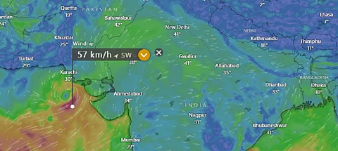

The very severe cyclonic storm Biparjoy that formed over east-central Arabian Sea has been moving nearly northwards at a speed of five kilometres per hour (kmph) during the last six hours, according to the India Meteorological Department (IMD).
The system is expected to gradually intensify further during the next 18 hours and move nearly north-northwestwards during the subsequent three days.
The cyclone rapidly intensified from a depression to a deep depression and a cyclone on June 6. It developed into a severe and very severe cyclonic storm on June 7.
Vineet Kumar, Senior Research Fellow, Centre for Climate Change Research, Indian Institute of Tropical Meteorology, tweeted:
Rapid intensification of Cyclone Biparjoy in the last 24hrs. As per Joint Typhoon Warning Centre (JTWC), the system intensified by 40 knots (unit of speed) in 24 hours with a current wind speed of 70 knots.
On June 7, the wind speed reached 80 knots, data from JTWC showed. It has surpassed the average in the last two decades, Kumar wrote on Twitter.
The wind speed is also increasing. The average maximum windspeed of Arabian Sea pre-monsoon season cyclones in the last two decades is 75 knots, which is 39 per cent more than the 1980-1999 average, Kumar said based on findings from his report.
Between 1980–2019, Cyclone Gonu in June 2007 — the strongest cyclone in the Arabian Sea — had a maximum wind speed of 145 knots, according to Kumar’s 2022 paper.
The track of the cyclone is not conclusive. The European Centre for Medium-Range Weather Forecasts model, as visualised by the software Windy, currently shows that the system is moving towards Karachi and Gujarat.
Another weather forecast model, Global Forecast System, predicts a different track. Data visualised by Windy shows that it will likely make landfall in Oman on June 14.
Further, the monsoon arrived in Kerala on June 8. It was expected on June 1. The southwest Monsoon has moved to the remaining parts of the south Arabian Sea and some parts of the central Arabian Sea, the Lakshadweep area, most parts of Kerala, most parts of south Tamil Nadu, remaining parts of Comorin area, the Gulf of Mannar and some more parts of southwest, central and northeast Bay of Bengal today on June 8, 2023.
The IMD has further predicted that conditions are favourable for further movement of the southwest monsoon into some more parts of the central Arabian Sea, remaining parts of Kerala, some more parts of Tamil Nadu, Karnataka, southwest, central and northeast Bay of Bengal as well as the northeastern states during the next 48 hours.
Cyclone Biparojy is likely influencing the monsoon, which probably caused the delay in the monsoon onset, according to experts.